
Indus Valley Civilization: Part 2
Indus Valley Civilization: A Comprehensive Study
The Indus Valley Civilization stands as one of humanity's earliest and most sophisticated urban cultures, spanning an enormous geographical area from the mountains of Afghanistan to the coasts of Gujarat. This document explores the multifaceted aspects of Harappan society—from their agricultural innovations and extensive trade networks to their enigmatic religious practices and political structures. Understanding this civilization is crucial for UPSC aspirants seeking to grasp the foundations of Indian history and the complex processes that shaped the subcontinent's cultural heritage.
Subsistence Patterns and Environmental Context
The Harappan civilization flourished across diverse ecological zones—alluvial plains, mountains, plateaus, and sea-coasts—each contributing unique resources to sustain urban life. This ecological variety proved crucial, as the failure of one resource could be compensated by others, providing resilience to the civilization. Agriculture formed the backbone of the economy, supplemented by animal husbandry, hunting, and exploitation of riverine and marine resources where available.
Sources of Information
Plant remains and seeds
Animal bones
Agricultural artifacts
Seal and pottery motifs
Modern practice analogies
Climate Debate
Wheeler suggested wetter conditions
Evidence from burnt bricks and embankments
Animal depictions indicating forests
Counter-evidence from lake studies
Issue remains unresolved
Agricultural Base
Wheat and barley cultivation
Rice in certain regions
Millets and pulses
Cotton and sesamum
Regional crop variations
Agricultural Practices and Regional Variations
Cropping Patterns
The Harappans demonstrated sophisticated agricultural knowledge adapted to regional conditions. In Sindh, where rainfall was low but the Indus brought fertile silt, farmers practiced flood-recession agriculture requiring no deep ploughing or irrigation. Sesamum and cotton were sown as kharif (summer) crops in June-July and harvested in September-October, while wheat and barley served as rabi (winter) crops, sown in November and reaped in March-April.
Gujarat's agricultural calendar differed, with rice cultivated as a kharif crop. This regional variation in cropping patterns demonstrates the Harappans' ability to adapt their agricultural practices to local environmental conditions, contributing to the civilization's long-term sustainability.
Regional Crops
Mohenjodaro: Wheat, barley
Harappa: Wheat, watermelon, peas, dates, sesamum
Kalibangan: Barley, rice
Lothal: Rice
Rangpur: Rice
Surkotada: Millets
Shortughai: Millets
The similarity between ancient and modern plant economies in various regions suggests remarkable continuity in agricultural traditions.
The plough, evidenced by a ploughed field discovered at Kalibangan and terracotta models from Bahawalpur and Banawali, was a crucial agricultural implement. Though no actual wooden ploughs have survived, their continued use into the mature Harappan phase can be confidently inferred. Irrigation techniques included building bunds (embankments) to divert river water, as practiced in Baluchistan, and possibly canal systems, though evidence for extensive canal networks in alluvial plains remains difficult to identify archaeologically.
Animal Resources: Domestication and Hunting
The Harappans exploited both wild and domesticated animal resources, demonstrating a comprehensive approach to protein procurement and labor management. This dual strategy provided both sustenance and essential support for agricultural and transportation activities.
Domesticated Animals
Cattle (humped and humpless) and buffaloes were the most important domesticated animals, used for meat, milk, and as draught animals. Goats and sheep provided meat, wool, milk, and served as pack animals. Dog figurines suggest domestication of this companion animal. The controversial horse remains have been reported at several sites, though their identification remains debated.
Wild Animals
Bones of deer, wild pig, boar, sheep, goat, and ass indicate hunting activities. Rhinoceros bones occur only at Amri, though depicted frequently on seals. Elephant and camel bones are rare, despite seal representations. Tigers, leopards, rabbits, peacocks, pigeons, ducks, and monkeys appear in figurines and pottery paintings.
Marine Resources
Coastal Harappan sites exploited riverine and marine resources extensively. Molluscs provided protein-rich diet elements at Gujarat coastal sites. Marine catfish bones at Harappa suggest trade in dried fish from coastal to inland cities. Tortoise and various fish bones demonstrate diverse aquatic resource utilization.
Religious Beliefs and Objects of Worship
Determining the religious beliefs of the Harappans presents significant challenges, as their script remains undeciphered and material remains must speak for themselves. Unlike contemporary Egyptian and Mesopotamian civilizations with their monumental temples and royal statues, the Indus Valley lacks clear religious structures, suggesting that ceremonies may have been conducted in individual homes or open air settings.
Mother Goddess Worship
Large numbers of terracotta female figurines with distinctive fan-shaped headdresses, wearing short skirts and heavy ornamentation, are frequently interpreted as mother goddesses. Some depict pregnancy or are shown with infants, suggesting fertility cult associations. A seal showing a nude woman with a plant issuing from her vagina may represent the Earth Mother prototype of Shakambari.
The Pashupati Seal
The famous "Pashupati seal" from Mohenjodaro depicts a male figure in yogic posture wearing a buffalo-horned headdress, flanked by four animals (elephant, rhinoceros, water buffalo, tiger) with two antelopes beneath. Marshall identified this with Pasupati (Lord of Beasts), suggesting proto-Shiva characteristics, though this interpretation remains debated.
Sacred Trees and Animals
The pipal tree appears frequently on seals and may have been venerated. Seals show figures looking through branches or worshippers standing before trees. Animals like the humped bull, elephant, rhinoceros, and tiger likely held cultic significance. Composite animals (tiger-human, bull-elephant) and the mythical unicorn suggest religious or mythological importance.
Ritual Practices and Sacred Structures
The Great Bath at Mohenjodaro
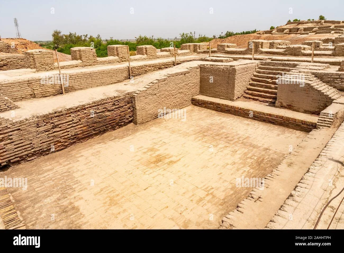
The Great Bath at Mohenjodaro
The Great Bath, a sunken rectangular basin at Mohenjodaro, probably served as the scene of elite ritual activity involving ceremonial bathing. Its elaborate construction with three concentric zones, streets on all four sides making it the only free-standing structure, and the careful waterproofing suggest profound ritual significance. Such bathing arrangements became characteristic of sacred spots in subsequent Indian historical phases.
Fire Altars and Sacrifices
At Kalibangan, raised brick platforms crowned with fire altars—brick-lined pits containing ash and animal bones—were discovered in the citadel. This complex included wells and bathing places, suggesting a ritual centre for animal sacrifice, ablution, and fire rituals. Many houses in the lower town also contained rooms with fire altars. Lothal also revealed fire altar evidence, indicating varied regional practices.
Additional ritual evidence includes lingas and yonis (fertility symbols), terracotta masks and puppets for religious performances, triangular cakes suggesting animal sacrifice, and a cylinder seal from Kalibangan possibly depicting human sacrifice. The diversity of these practices across different Harappan settlements reflects the complex, multi-faceted nature of urban religious life, unlike the uniformity found in tribal societies.
Funerary Practices: Beliefs About the Afterlife
While the Harappan civilization lacked monumental tombs comparable to Egyptian pyramids or Mesopotamian royal cemeteries, their burial practices reveal beliefs about death and afterlife. Principal burial sites include Harappa, Kalibangan, Rakhigarhi, Lothal, Rojdi, and Ropar, each showing variations in funerary customs.
Extended Burials
The most common method involved placing the deceased in extended position, head towards the north, in simple pits or brick chambers. Grave goods including pottery, tools, and ornaments accompanied the body, though never lavishly, suggesting the Harappans valued wealth in life over burial displays.
Coffin and Urn Burials
At Harappa, a woman's body was found in a wooden coffin lined with reed mats. Urn burials at Mohenjodaro and Harappa point to cremation practices. Pot burials, where bodies were crammed into pots, occurred at Kalibangan, representing a rare burial type.
Multiple and Symbolic Burials
Lothal revealed simultaneous burial of two persons in the same grave pit, possibly suggesting sati practice, though this remains doubtful. Kalibangan showed symbolic burials with grave goods but no skeletal remains. Fractional burials (where bones were gathered after exposure and then buried) occurred at Mohenjodaro and Harappa.
The variety in burial practices—even within single settlements like Kalibangan—reflects the social complexity of urban centres. Unlike tribal societies with uniform customs, Harappan cities comprised diverse social groups with distinct religious practices, suggesting political and economic integration of varied communities. The careful placement of bodies with ornaments and toiletries indicates belief in some form of afterlife, though cremation (predominant in later historical phases) was not the primary disposal method.
Internal Trade Networks and Rural-Urban Relations
Urban economies depend on vast networks transcending physical boundaries. Harappan cities, with significant non-food-producing populations engaged in administrative, religious, trading, and manufacturing functions, relied heavily on surrounding countryside for food supplies. This relationship was fundamentally unequal—cities attracted wealth through taxes, tributes, gifts, and purchases, controlled by powerful urban sections.
Resource Distribution
Villages supplied essential food grains and raw materials to towns. Granaries at Mohenjodaro and Harappa indicate rulers' attempts to secure assured food supplies, collecting grains from surrounding villages for redistribution to townsmen. The Harappan towns' location in the most fertile available areas—such as Mohenjodaro in Larkana district—facilitated this grain collection.
Urban Contributions
In return, urban centres collected items unavailable locally and supplied them to rural hinterlands. Stone tools—parallel-sided blades made from high-quality stone from sites like Sukkur in Sindh—were distributed widely. Copper-bronze tools showing design uniformity across Harappan sites indicate centralized production and distribution by merchants or administrators.
Evidence from sites like Rangapur in Gujarat demonstrates this urban-rural dependency: during the urban Harappan phase, people used stone tools from distant areas, but after civilization decline, they reverted to locally available stones. Precious stones and metals filtered from cities to wealthy individuals in villages and towns, though exchange occurred through barter rather than metal money. This intensive network linked settlements across hundreds of miles, forming the economic backbone of Harappan urbanism.
Sources and Distribution of Raw Materials
The diversity of objects discovered at Harappan sites—bangles, beads, pottery, copper, bronze, and stone implements—reveals an extensive procurement network for metals and precious stones not uniformly available across the civilization's expanse. Even small settlements yielded precious materials, indicating intensive exchange networks serving elite needs.
Minerals and Metals
Copper: Khetri (Rajasthan), Baluchistan, North-West Frontier
Tin: Tosam (Haryana), Afghanistan, Central Asia
Gold: Kolar (Karnataka), upper Indus sands
Lead: Kashmir, Rajasthan, South India
Silver: Afghanistan, Iran, possibly Mesopotamia
Precious Stones
Lapis Lazuli: Badakshan (North-East Afghanistan)
Carnelian, Agate: Gujarat
Turquoise: Central Asia
Jade: Central Asia
Sea-shells: Gujarat coast, western India
Production Centres
Stone blades: Sukkur and Rohri limestone hills (mass production)
Shell working: Balakot, Chanhudaro
Bead making: Lothal, Chanhudaro
Metallurgy: Mohenjodaro, Harappa, Lothal
Timber: Kashmir mountain zones (via Manda)
Factory sites in Sukkur and Rohri hills produced chert blades for distribution to Sindh settlements. Links between copper-manufacturing Ganeshwar-Jodhpura culture and Harappan civilization suggest importing copper tools from pastoralist and hunter communities. The Harappan outpost at Shortughai in Afghanistan confirms exploitation of lapis lazuli sources. Cities specialized in different crafts, with Mohenjodaro hosting diverse craft specialists—stone workers, potters, copper and bronze workers, brick-makers, seal-cutters, and bead-makers.
Transportation and Major Trade Routes
The movement of goods and people across the vast Harappan culture zone required sophisticated transportation networks utilizing both land and water routes. Traders transported merchandise in caravans of pack animals—oxen, sheep, goats, and donkeys—with two-wheeled bullock carts serving as the primary transport mode, evidenced by terracotta models and copper or bronze cart models with drivers from Harappa and Chanhudaro.
Land Routes
Major routes connected Sindh with south Baluchistan, coastal Sindh with upper Sindh and central Indus plains, Indus plains with Rajasthan, Sindh with east Punjab, east Punjab with Rajasthan, and Sindh with Gujarat. The north Afghanistan-Gomal plain-Multan route with feeder to Taxila valley remained important.
River Transport
The Indus and its tributaries witnessed considerable riverine traffic. Boats depicted on seals and moulded tablets, plus clay models from Harappa and Lothal, show vessels with cabins, roof ladders, and high stern platforms for navigation. Mohenjodaro's strategic location at the Indus water-route and east-west land route intersection exemplifies site placement logic.
Coastal Ports
A coastal route linked Gujarat sites (Lothal, Dholavira) to Makran coast sites (Sutkagen-dor). The Arabian Sea coastline featured multiple sea-ports—Rangapur, Somnath, Balakot. Sites on the inhospitable Makran coast (Sutkagen-dor, Sutkakoh) provided safe anchorage during monsoon storms, offering Harappan ships stopping points to the Persian Gulf.
Strategic site locations often related to trade routes. Mohenjodaro's position at the intersection of Indus water transport and the east-west land route connecting Quetta valley and Bolan river to Kot Diji demonstrates this principle. Harappa's advantageous location within 300 km of multiple resources—access to Hindukush passes (for turquoise and lapis lazuli), salt range, Rajasthan minerals (tin, copper), Kashmir sources (amethyst, gold), timber zones, and the confluence point of Punjab's five rivers—enabled control of river transport and resource procurement, explaining its growth into a major city despite no particular agricultural advantage.
External Trade: Connections with West Asia
Beyond internal exchange, Harappans maintained commercial contacts with western neighbours through both overland and maritime routes. Lothal, Surkotada, and Balakot served as important coastal trading towns connecting to Mesopotamia and West Asian sites. Two main overland routes linked the Harappan civilization with West Asia: a northern route through Afghanistan, north Iran, Turkmenistan, and Mesopotamia; and a southern route through Tepe Yahya, Jalalabad, and Ur.
Mesopotamian Trade Evidence
Mesopotamian records from 2350 BCE onwards reference trade with Meluha (ancient Indus region), describing it as a land of seafarers. King Sargon of Akkad boasted that ships from Dilmun (Bahrain), Magan (Makran coast and Oman), and Meluhha moored at his capital. Mesopotamian texts mention Meluhhans living in Mesopotamia and even an official interpreter of the Meluhhan language.
Archaeological evidence includes Harappan seals and carnelian beads at Mesopotamian sites (Kish, Nippur, Lagash, Ur), including royal graves at Ur. Bull motifs on Mesopotamian seals suggest Harappan influence. However, the absence of Mesopotamian seals in Harappan contexts suggests Mesopotamian traders weren't directly involved in this exchange.
Persian Gulf Intermediaries
Sites in the Persian Gulf region served as intermediary trading posts. Harappan artifacts found at Bahrain (Ras-al-Qala, Hamad) include typical seals, circular mirrors, and carnelian beads. Failaka (Kuwaiti Island) yielded a round seal with short-horned bull and Harappan writing. Oman peninsula sites (Umm-an-Nar, Maysar) show Harappan influence through carnelian beads, pottery decorations, and seal motifs.
The scarcity of Mesopotamian goods in Harappan sites (explainable by their perishable nature—garments, wool, oils, leather) and Persian Gulf intermediary evidence suggest indirect rather than direct Harappan-Mesopotamian trade, possibly through Persian Gulf merchants.
Trade Commodities and Exchange Systems
Harappan trade involved diverse commodities moving between regions and across international boundaries. Internal trade included food grains transported between villages and cities, with rice imported from Gujarat to Punjab and cotton from Lothal and Surkotada supplying developing townships. Specialized craft centres like Balakot and Chanhudaro produced shell-work and bangles, while Lothal and Chanhudaro manufactured carnelian beads.
Cubical Weights
Number of weight standards in the binary system used by Harappans
Foot Unit (cm)
Standard unit of length measurement across Harappan sites
Inscribed Objects
Total number of seals, sealings, and inscribed items discovered
Mesopotamian texts list Harappan exports: lapis lazuli, carnelian, gold, silver, copper, ebony, ivory, tortoiseshell, exotic birds, dogs, cats, and monkeys. Mesopotamian exports included fish, grain, raw wool, woolen garments, and silver—the latter possibly explaining silver's presence in Harappan sites despite no known local sources. Textiles and conch shell objects were other probable Harappan exports to West Asia.
The Harappans regulated trade through uniform systems. Weights followed a binary system (1, 2, 4, 8 to 64, then 160, 320, 640, etc.) and were typically cubical, made of chert, limestone, or steatite. Length measurements used a foot unit of 37.6 cm and cubit of 51.8-53.6 cm. Seals and sealings—marks of ownership guaranteeing product quality—were extensively used, with cord and matting impressions indicating attachment to merchandise bales. However, instead of metal money, Harappans preferred barter exchange systems.
Assessment of Harappan Trade Networks
Scholarly assessments of Harappan trade, particularly with Mesopotamia, vary considerably. Ratnagar emphasizes its importance, especially lapis lazuli trade, arguing its decline contributed to civilization collapse. However, the scarcity of Harappan artifacts in Mesopotamia and vice versa suggests limited exchange. Chakrabarti and Shaffer contend that Harappan-Mesopotamian trade was neither direct, extensive, nor intensive, and not crucial for Harappan development or sustenance.
Unlike resource-poor Mesopotamia, the Harappan culture zone possessed diverse natural resources. Food requirements and most raw materials needed by craftspersons could be met within the Harappan zone. Well-developed craft traditions meant most finished goods were available internally. Few essential items required distant importation. This self-sufficiency suggests long-distance trade, while existing, wasn't fundamental to Harappan prosperity.
Trade Characteristics
Highly organized merchant groups
Nomadic peddlers in mountains
Debated state control extent
Strategic outposts (Shortughai)
Specialized site functions
Standardized systems
The quantum of long-distance trade appears modest compared to internal exchange. Site locations often reflected trade route proximity or industrial specialization rather than agricultural potential. Sutkagen-Dor on the inhospitable Makran Coast exemplifies this—established primarily as a Harappan-Mesopotamian trading post despite poor agricultural yields. The presence of highly organized merchant groups, alongside nomadic peddlers, facilitated this complex exchange network, though the precise extent of state control remains debated.
The Harappan Script: An Enduring Mystery
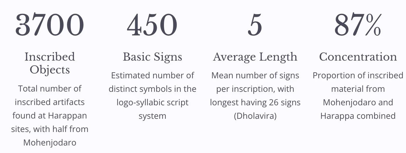
Among the greatest mysteries surrounding the Harappan civilization are the language spoken by its inhabitants and their writing system. Despite discovering thousands of inscribed objects, the script remains undeciphered, preventing direct access to Harappan thoughts, beliefs, and historical records. The brevity of most inscriptions—averaging five signs—and the absence of bilingual texts have thwarted decipherment attempts.
The Harappan Script: An Enduring Mystery
The script appears fully evolved from its earliest occurrences, showing no significant changes over time—unusual compared to other ancient writing systems that evolved gradually. This stagnation suggests limited use, perhaps restricted to a small privileged class of scribes with monopoly over writing, unlike contemporary Mesopotamia where scribal schools trained new generations. The script generally reads right to left (reversed on seals), with occasional left-to-right instances and boustrophedon style (alternating directions) in longer texts.
Scholars debate whether Harappan belonged to Dravidian or Indo-Aryan language families, but no consensus exists. Multiple languages and dialects were likely spoken across the vast culture zone, with the script possibly representing the ruling elite's language. The virtual disappearance of writing by 1700 BCE suggests both its close connection to urban life and insufficient downward percolation into broader society.
Functions and Uses of Seals and Sealings
Seal-making represented an important Harappan craft, with most seals being square or rectangular, though some cylindrical and round examples exist. Typically crafted from steatite, with rare silver, faience, and calcite specimens, these seals bore short inscriptions and distinctive imagery. Understanding their functions provides crucial insights into Harappan socio-economic and religious life.
Economic Functions
Seals were impressed onto small moist clay tablets (sealings), probably by merchants to authenticate merchandise bales—supported by textile impressions on some sealings. However, more seals than sealings have been found, and seals show edge wear rather than internal wear, suggesting additional functions. They may have served as tokens in buying and selling goods, or as identification markers (like modern identity cards) for landowners, merchants, priests, artisans, and rulers, symbolizing families or clans.
Social and Religious Functions
Animals on square stamp seals possibly represent totemic symbols for specific clans. Kenoyer identifies at least ten clans/communities: unicorn, humped bull, elephant, water buffalo, rhinoceros, humpless short-horned bull, goat, antelope, crocodile, and hare. The unicorn motif's prevalence at major cities—over 60% at Mohenjodaro, 46% at Harappa—led Ratnagar to suggest it symbolized the ruling elite. Kenoyer alternatively argues the unicorn clan represented aristocracy or merchants with executive governmental roles, while less frequent motifs (bull, elephant, rhinoceros, tiger) may have symbolized the most powerful rulers.
Seals provide information about dresses, ornaments, and hairstyles, exhibiting artists' and sculptors' skills. They depict both river boats and seafaring vessels used for internal and external trade. Broken seals suggest intentional destruction when no longer in use to prevent misuse. Writing on seals probably represented the ruling elite's language. The discovery of Harappan seals in Central Asia, Persian Gulf, and Mesopotamian sites helps reconstruct external trade networks and inter-regional interactions.
Political Organization: Debates and Evidence
Mortimer Wheeler described the Harappan civilization as "the vastest political experiment before the advent of the Roman empire," yet the nature of this experiment remains conjectural. The 700-year continuity of Harappan traditions and artifacts suggests strong political stability, but determining the precise political structure proves challenging without deciphered texts.
Centralized Empire Theory
Piggott and Wheeler proposed a highly centralized empire ruled by autocratic priest-kings from twin capitals Mohenjodaro and Harappa. Evidence: uniformity in material traits, common script, standardized weights and measures, urban planning, monumental public works, and apparent lack of internecine warfare. The 'granaries' suggested centralized control over food stocks.
Village Administration Theory
Fairservis argued against state or empire existence, pointing to absent priest-kings, slaves, standing armies, and court officials. He suggested elaborate village administration could explain observed control levels, with Mohenjodaro as a ceremonial rather than administrative centre. Religion and tradition, not force, regulated social behaviour.
Chiefdom State Theory
Malik characterized the Harappan polity as a chiefdom—transitional between kinship and civil state society. The lack of imposing monuments and supreme gods contradicts strong centralized state ideas. Jacobson's "early state" model features sovereigns linked to mythical characters, weak military component, and weakly developed economic stratification.
Corporate/Council Theory
Possehl emphasizes corporate character—Harappan society was highly disciplined with strong corporate elements, possibly ruled by councils rather than kings. Kenoyer suggests multiple competing classes of urban elites (merchants, ritual specialists, resource controllers) with different control levels and spheres, rather than single centralized authority.
The absence of marked social/economic differences and Egyptian/Mesopotamian-style tombs or palaces doesn't negate state existence—rather it indicates a different state type. Communications systems, artifact standardization, site specialization, labour mobilization for public works, and Shortughai's establishment indicate economic complexity requiring state structures. Cultural homogeneity and common writing across linguistically diverse areas further suggest state-level organization, though whether it was a centralized empire or network of inter-related states remains unresolved.
Urban Decline: Archaeological Evidence
By 2200 BCE, decline had set in at Mohenjodaro, with the settlement ending by 2000 BCE, though in some places the civilization continued until 1800 BCE. The pace of decline varied—Mohenjodaro and Dholavira show gradual deterioration, while Kalibangan and Banawali experienced sudden endings. Cities like Harappa and Mohenjodaro witnessed gradual decline in urban planning and construction quality.
Architectural Decay
Houses constructed with old, dilapidated bricks and shoddy workmanship encroached upon roads and streets. Flimsy partitions subdivided courtyards. Cities transformed into slums. At Mohenjodaro, many entry points to the Great Bath were blocked, which later fell into total disuse along with the Granary.
Material Culture Decline
Late levels at Mohenjodaro showed distinct reduction in sculptures, figurines, beads, bangles, and inlay works. The city shrank from 85 hectares to merely 3 hectares before abandonment. Similar decay processes occurred at Kalibangan and Chanhudaro, with buildings associated with power and ideology deteriorating.
Settlement Pattern Changes
In the Bahawalpur-Hakra river area, settlements declined from 174 in Mature Harappan to 50 in Late Harappan period. Conversely, outlying areas (Gujarat, East Punjab, Haryana, upper Doab) witnessed phenomenal settlement increases, suggesting population migration from core regions.
Abandonment
Major cities were eventually abandoned altogether, dated roughly to 1800 BCE—supported by Mesopotamian literature ceasing references to Meluhha by 1900 BCE. Important Harappan features—writing, uniform weights, distinctive pottery, architectural styles—disappeared from outlying regions, though people continued living with changed lifestyles.
Theories of Decline: Aryan Invasion and Natural Disasters
Scholars have proposed various theories explaining the Harappan civilization's end, ranging from catastrophic single events to gradual processes. Understanding these theories is crucial for comprehending the complex factors contributing to one of history's most significant urban collapses.
Aryan Invasion Theory
Wheeler argued that Aryan invaders destroyed the civilization, pointing to skeletal remains at Mohenjodaro as massacre evidence. Rig Vedic references to forts, walled city attacks, and Indra as "purandara" (fort destroyer) seemed to describe Harappan cities. He identified Hariyupiya in the Rig Veda with Harappa.
Criticism: The Rig Veda's uncertain dating makes it inconclusive. No archaeological evidence of military assault or conflict exists. The 37 skeletal groups at Mohenjodaro belong to different cultural phases, not a single event. None were found on the citadel where major battles would occur. Cemetery-H culture (Wheeler's proposed Aryan invader culture) is separated by a sterile layer from mature Harappan levels. The provisional decline date (1800 BCE) precedes the Aryan arrival (not earlier than 1500 BCE).
Floods and Earthquakes
Multiple silt layers at Mohenjodaro suggest repeated catastrophic flooding, with deposits up to 80 feet above ground level. Sahni, Raikes, and Dales proposed tectonic movements created natural dams blocking the Indus, submerging cities. Coastal sites like Sutkagedor now located far inland suggest violent tectonic uplifts.
Criticism: Lambrick argues that large Indus water volume would breach any earthquake-created bund. Silt deposition in a hypothetical lake would parallel rising water surface along the former river course, not create Mohenjodaro's silt pattern. The theory fails to explain decline of settlements outside the Indus system.
Theories of Decline: Environmental and Climatic Factors
Environmental explanations for Harappan decline focus on ecological imbalance and climate change—factors that could affect the entire civilization rather than individual sites. These theories have gained increasing acceptance as evidence accumulates for significant environmental changes during the relevant period.
Ecological Imbalance Theory
Fairservis proposed that growing populations of people and cattle exceeded the limited production capacities of semi-arid areas. Over-exploitation through over-cultivation, overgrazing, and excessive tree-cutting for fuel and farming disturbed the delicate ecological balance. Forests and grass cover gradually disappeared, decreasing soil fertility and increasing salinity, floods, and droughts. This subsistence base depletion caused economic strain, prompting movement to areas offering better subsistence possibilities—explaining migration towards Gujarat and eastern areas.
Climate Change and Desiccation
Agarwal and Sood linked decline to increasing aridity and the Ghaggar-Hakra river system drying up by mid-second millennium BCE. In semi-arid regions, even minor moisture reduction could devastate agriculture, stressing city economies. Tectonic disturbances caused Sutlej to join the Indus and Yamuna to shift eastward to the Ganges, leaving the Ghaggar waterless with catastrophic implications. Mughal's settlement studies show drastic site reduction as the river dried. The 2012 Monsoon Link Theory suggests weakening monsoons made climate unfavourable, evidenced by Saraswati River (rain-fed) disappearance.
Recent Research Findings
IIT Kharagpur-ASI-PRL 2020 study connected Dholavira's decline to Himalayan snow-fed river disappearance and Meghalayan drought. Mangroves around the Rann and glacial-fed rivers (resembling mythological Saraswati) provided water until approximately 3,800 years ago. Woods Hole Oceanographic Institution (2018) used undersea fossil evidence showing winter monsoon increase caused summer monsoon gradual drying, making Indus Valley agriculture difficult but benefiting foothill regions. Seafloor sediments near the Indus mouth revealed stronger winter monsoons and weaker summer monsoons during later Harappan civilization years.
Environmental disaster theories face some challenges: the subcontinent's enduring soil fertility over subsequent millennia contradicts soil exhaustion hypotheses. However, the evidence for climate change appears increasingly persuasive, particularly when combined with archaeological settlement pattern data showing eastward and southward population shifts.
Late Harappan Phase and Cultural Continuity
Modern scholarship no longer seeks single causes for Harappan decline, recognizing instead a gradual de-urbanization process. While cities were abandoned and urban features disappeared, the civilization didn't vanish—it transformed. The late Harappan phase represents not collapse but cultural change, regional migration, and settlement system modification.
Sindh Region
Jhukar culture at Chanhudaro and Amri showed gradual transition without sudden discontinuity. Seals changed, writing confined to pottery, planned layouts abandoned, but distinctive Jhukar pottery evolved from mature Harappan types. Metal objects suggest Iranian or Central Asian contacts.
Punjab-Haryana
Cemetery-H culture in western Punjab and Ghaggar-Hakra valley showed settlement decline from 174 to 50 sites. East Punjab-Haryana-Rajasthan sites (Mitathal, Bara, Ropar, Siswal) were smaller with brick houses at some locations. Regional pottery traditions gradually replaced Harappan styles.
Ganga-Yamuna Doab
Sites increased dramatically from 31 mature Harappan to 130 late Harappan settlements. Settlements were small, houses typically wattle-and-daub, but agricultural base was diverse. This expansion suggests eastward population migration.
Gujarat Region
Sites multiplied from 13 to over 200 in Late Harappan phase—unexplainable by natural population growth, suggesting immigration. Sites like Rangapur became more prosperous. Lustrous Red Ware pottery emerged, though Indus weights, script, and imported tools disappeared.
Elements of Continuity
Despite urban collapse, numerous Harappan traditions survived: pottery shapes (jars, dish-on-stand) continued though less refined; graffiti on pottery in Gujarat and eastern regions; faience ornaments and bead-making continued; metallurgical traditions persisted; agricultural diversification (double cropping at Pirak, rice and millets at Harappa). Sites like Bhagwanpura show overlaps between late Harappan and Painted Grey Ware cultures, while western Uttar Pradesh shows late Harappan-Ochre Coloured Pottery overlaps.
Cultural Transmission
Many Harappan elements survived into historical India: Pasupati (Shiva) and mother goddess cults, phallic worship, sacred places/rivers/trees/animals reverence, fire worship and sacrifice, house plans and bathing arrangements, weight systems (ratio of sixteen), pottery wheel techniques, bullock carts and boats. Rather than sudden collapse, the evidence reveals cultural transformation, regional diversification, and gradual transmission of traditions to subsequent civilizations.