
India: Location, Extent and Borders

India: Location
India, the seventh largest country in the world, occupies a distinct and unique geographical entity that is beautifully bounded by majestic mountains and expansive seas. With its vast expanse stretching elegantly from the snow-capped Himalayas to the warm, inviting shores of the Indian Ocean, India's geography encompasses a remarkable variety of landscapes, including lush plains, arid deserts, and extensive coastlines, while also sharing its borders with seven neighboring countries. This comprehensive document aims to thoroughly explore India's geographical positioning, its intricate boundaries, diverse coastal regions, and the complex geopolitical frontiers that intricately define and shape the nation.
Location and Extent of India
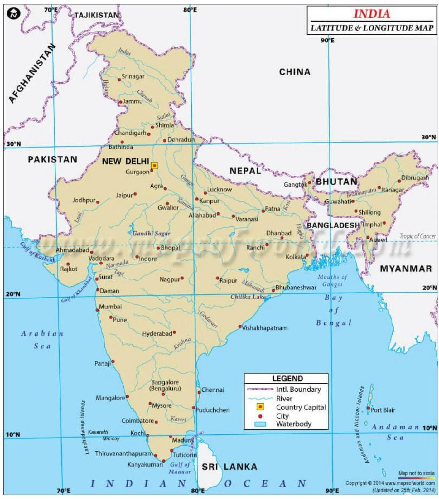
India is located entirely in the northern hemisphere, specifically in the south-central part of the continent of Asia. The mainland extends between latitudes 8°4'N and 37°6'N and longitudes 68°7'E and 97°25'E. As the 7th largest country in the world, India stands apart from the rest of Asia, marked off by mountains and seas, which gives the country a distinct geographical entity.
India has a land boundary of about 15,200 km and the total length of the coastline of the mainland, including Andaman and Nicobar and Lakshadweep, is 7,516.6 km. The country is bounded by the young fold mountains in the northwest, north, and northeast. South of about 22° north latitude, India begins to taper and extends towards the Indian Ocean, dividing it into two seas, the Arabian Sea on the west and the Bay of Bengal on its east.
The latitudinal and longitudinal extent of the mainland is about 30°. Despite this fact, the east-west extent appears to be smaller than the north-south extent. From Gujarat to Arunachal Pradesh, there is a time lag of two hours, which necessitates a standard time for the country.
Location and Extent of India
Key Geographical Measurements of India
The north-south extent from Indira Col in Kashmir to Kanniyakumari is 3,214 km, while the east-west width from the Rann of Kachchh to Arunachal Pradesh is 2,933 km. With an area of 32,87,263 sq km, India accounts for about 2.4 percent of the total surface area of the world. The southernmost point of the country is the Pygmalion Point or Indira Point, located at 6°45'N latitude.
The Tropic of Cancer (23°30'N) passes through the middle of the country, dividing it into two latitudinal halves. It crosses through eight states in India: Gujarat (Jasdan), Rajasthan (Kalinjarh), Madhya Pradesh (Shajapur), Chhattisgarh (Sonhat), Jharkhand (Lohardaga), West-Bengal (Krishnanagar), Tripura (Udaipur), and Mizoram (Champhai). Interestingly, the area to the north of the Tropic of Cancer is nearly twice the area which lies to the south of it.
South of 22° north latitude, the country tapers off over 800 km into the Indian Ocean as a peninsula. This peninsular configuration gives India its distinctive shape and contributes to its varied climate patterns across different regions.
Standard Time
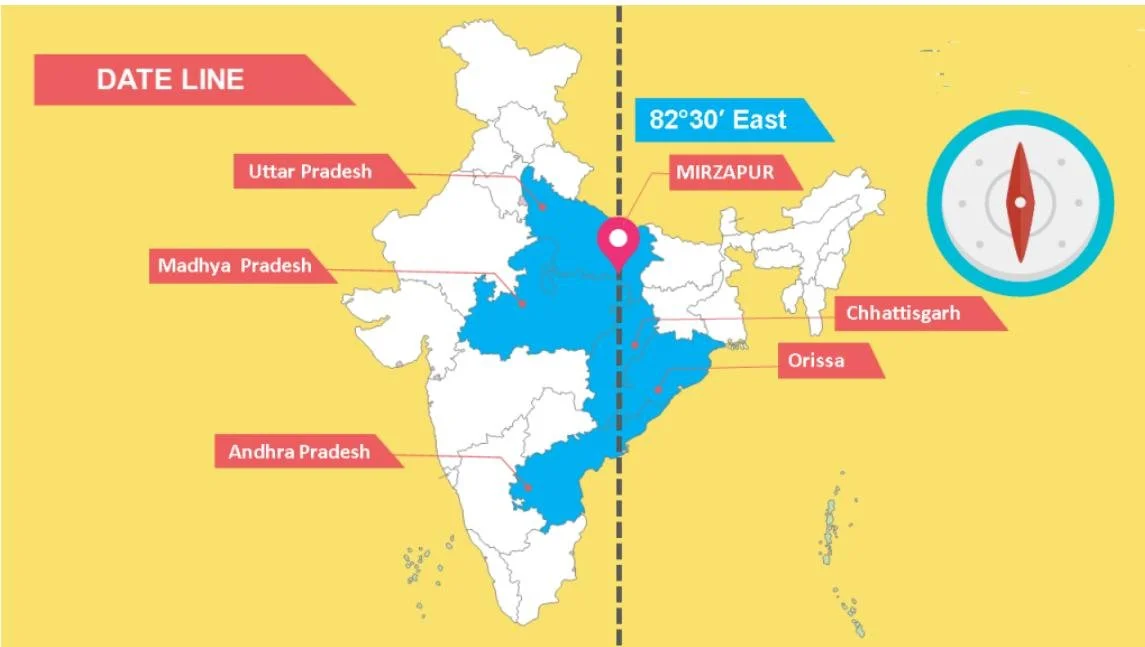
The Standard Meridian of India (82°30'E) passes through Mirzapur in Uttar Pradesh and is taken as the standard time for the whole country. This meridian was chosen to minimize the time difference between the easternmost and westernmost parts of India. The Indian Standard Time (IST) is 5 hours and 30 minutes ahead of Coordinated Universal Time (UTC).
The standard meridian passes through five states: Uttar Pradesh, Madhya Pradesh, Chhattisgarh, Odisha, and Andhra Pradesh. This arrangement ensures that the entire country follows a unified time zone despite spanning about 30° of longitude, which would normally correspond to a two-hour time difference.
Although the temperate part of India (north of the Tropic of Cancer) is twice the area of the tropical part, India has always been treated as a tropical country for both physical and cultural reasons. Physically, the country is separated from the rest of Asia by the Himalayas, and its climate is dominated by tropical monsoons, with temperate air masses blocked by the mountain range. Even in North India, where night temperatures in winter may drop to levels seen in temperate regions, clear skies and intense insolation raise day temperatures to tropical levels.
From a cultural geographic perspective, India's settlements, diseases, and primary economic activities are all tropical in nature, further cementing its classification as a tropical country despite its significant temperate zone.
Indian Standard Time
India's Land Borders: Overview and Significance
India shares land borders with seven countries, totaling 15,106.7 km and running through 92 districts across 17 states. According to the Ministry of Home Affairs, the country with which India shares its longest border is Bangladesh (4,096.7 km), while the shortest border is with Afghanistan (106 km). The other bordering countries include China (3,488 km), Pakistan (3,323 km), Nepal (1,751 km), Myanmar (1,643 km), and Bhutan (699 km).
All Indian states except Madhya Pradesh, Chhattisgarh, Jharkhand, Delhi, Haryana, and Telangana share either an international border or a coastline, making them "frontline states" from a border management perspective. This extensive frontier creates both opportunities and challenges for India's security, trade, cultural exchange, and diplomatic relations.
The management of these borders varies significantly based on terrain, historical relationships, and current geopolitical dynamics. Some borders, like that with Bhutan, are largely peaceful and uncontested, while others, such as those with Pakistan and China, involve complex territorial disputes and require sophisticated security arrangements.
India's border areas are not just security concerns but also vibrant zones of cultural confluence, trade, and human mobility that significantly influence the socioeconomic fabric of the border states. The government's approach to border management therefore balances security imperatives with the need to facilitate legitimate cross-border activities.
India-China Border: The Complex Frontier
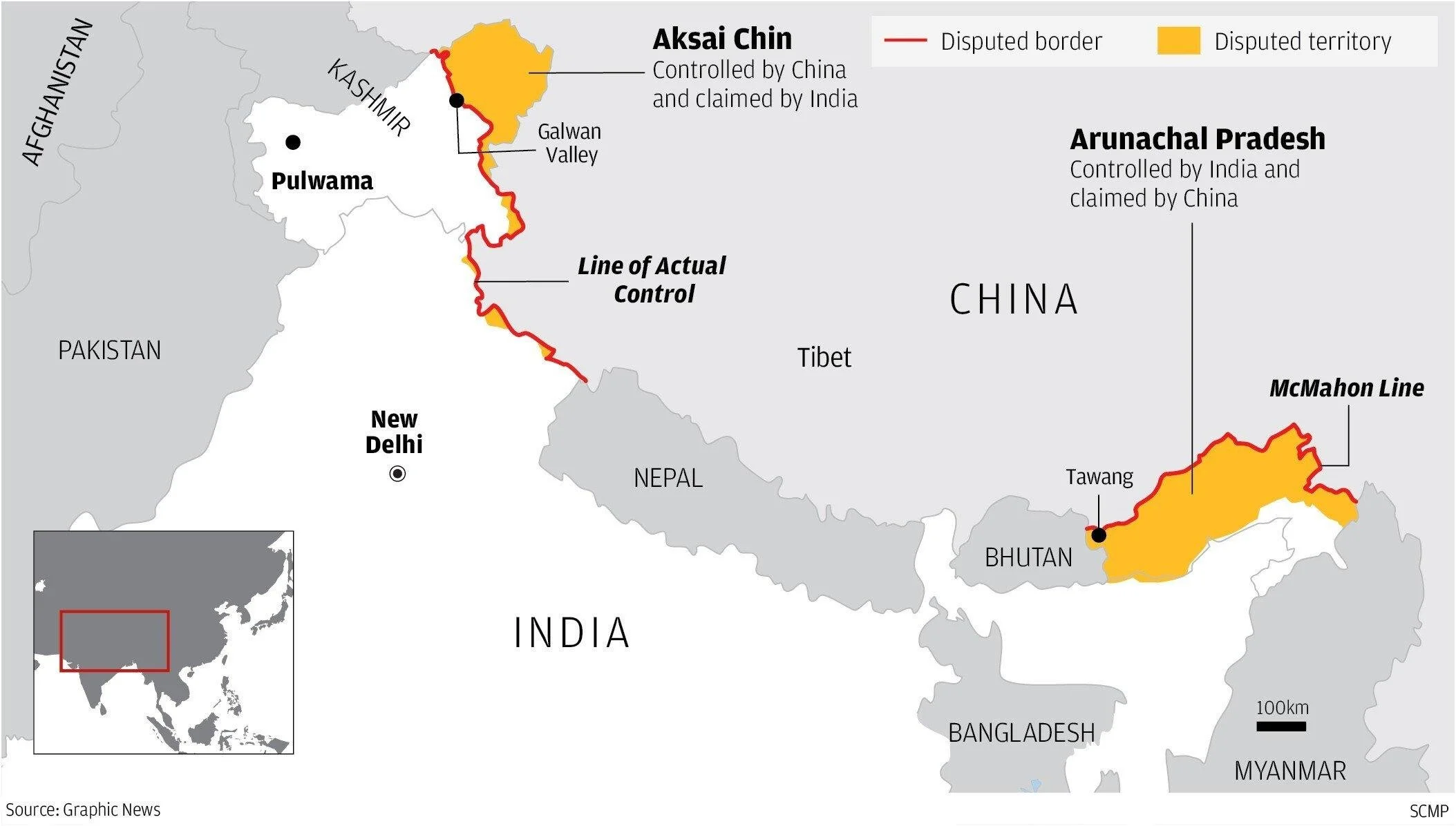
The India-China border, spanning approximately 3,488 km, is the second longest international border of India. This frontier touches five Indian states: Jammu and Kashmir (now the Union Territory of Ladakh), Himachal Pradesh, Uttarakhand, Sikkim, and Arunachal Pradesh. The Sino-Indian border is conventionally divided into three sectors: the Western, Middle, and Eastern sectors, each with its own distinct geographical and historical characteristics.
In the Western Sector, which separates the Union Territory of Ladakh from China's Xinjiang province, major disputes exist over the Aksai Chin region. The dispute stems from differing historical interpretations and border demarcations. India bases its claim on the Johnson Line (proposed in 1865), which shows Aksai Chin as part of the erstwhile Jammu and Kashmir state. China, however, follows the McDonald Line (proposed in 1893), which places it under Chinese control. Currently, the Line of Actual Control (LAC) serves as the de facto boundary, though its exact position remains contested.
The Middle Sector, touching Himachal Pradesh and Uttarakhand, is relatively less disputed. The Eastern Sector, covering approximately 1,140 km from eastern Bhutan to the Diphu pass near the India-Tibet-Myanmar trijunction, features the McMahon Line as the boundary. This line, established during the Shimla Accord of 1913-14, is accepted by India but rejected by China, which claims that Tibet did not have the authority to conclude treaties.
Beyond Aksai Chin, other disputed areas include the Changmo valley, Pangong Tso and Sponggar Tso areas in Ladakh, and the Huza-Gilgit area in North Kashmir, which Pakistan ceded to China in 1963 but is claimed by India as part of its territory.
India-China Border: The Complex Frontier
India-Nepal and India-Bhutan Borders
The India-Nepal border extends for 1,751 km and touches five Indian states: Uttarakhand, Uttar Pradesh, Bihar, West Bengal, and Sikkim. This frontier is characterized by its porous nature, allowing unrestricted movement of people and goods between the two countries, a unique arrangement facilitated by the 1950 Treaty of Peace and Friendship. A major portion of this border runs in an east-west direction along the foothills of the Shiwalik Range.
Despite the generally cordial relationship, there are two significant territorial disputes between India and Nepal. The Kalapani region, located at the western tri-junction of Nepal, India, and China, is administered by India as part of Uttarakhand's Pithoragarh district but claimed by Nepal as its westernmost territory. The dispute centers on the source of the Kali River, which according to the 1816 Treaty of Sugauli defines the border between the two nations. Another disputed area is Susta, located on the banks of the Gandak river (called Narayani in Nepal). The changing course of the river has complicated border demarcation, as Susta village, originally on Nepal's side, has shifted to the Indian side due to river movement.
In contrast, the India-Bhutan border, extending for 699 km, represents one of India's most peaceful international boundaries. There are no territorial disputes between the two countries, and relations are governed by the Treaty of Friendship and Cooperation, which was updated in 2007 to respect Bhutan's sovereignty while maintaining strong bilateral ties. The border runs through the states of Sikkim, West Bengal, Assam, and Arunachal Pradesh, crossing diverse terrain from the Eastern Himalayas to the foothills and plains.
India-Pakistan Border: Historical Context and Disputes
The India-Pakistan border, spanning 3,323 km, was established following the partition of British India in 1947 under the Radcliffe Award, named after Sir Cyril Radcliffe who chaired the boundary commission. This border touches four Indian states: Gujarat, Rajasthan, Punjab, and the Union Territory of Jammu and Kashmir. The frontier is one of the most heavily militarized in the world, reflecting the tense relations between the two nuclear-armed neighbors.
Several territories along this border remain disputed. The most significant is Jammu and Kashmir, where Pakistan occupies approximately 78,000 sq. km of Indian territory that India considers illegally held. Additionally, under the Sino-Pakistan Boundary Agreement of 1963, Pakistan ceded 5,180 sq. km of territory in Pakistan-occupied Kashmir to China, an action that India deems illegal.
The Siachen Glacier, located in the eastern Karakorams, represents another contested area. Since 1984, following Operation Meghdoot, India has administered the entire glacier including all major passes. Similarly, the Saltoro Ridge, a mountain range in the Karakoram, is claimed by both countries but has been under Indian military control since 1984, with Pakistani forces positioned in the glacial valleys to the west.
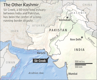
Sir Creek, a 96 km long tidal estuary in the marshlands of the Rann of Kutch, presents a maritime boundary dispute. Pakistan claims the boundary should follow the eastern shore of the estuary, while India argues for a median line down the creek's center. This disagreement stems from different interpretations of the 1914 Bombay Government Resolution and affects not only the creek itself but also potentially valuable offshore oil and gas rights.
India-Bangladesh Border: Challenges and Resolutions
The India-Bangladesh border, extending 4,096 km, is India's longest international boundary. It was established under the Radcliffe Award following the partition of Bengal during India's independence in 1947, and later redefined after Bangladesh's liberation from Pakistan in 1971. This extensive frontier touches five Indian states: West Bengal, Assam, Meghalaya, Tripura, and Mizoram, creating a complex border management challenge.
Despite the cultural and historical ties between the two nations, the border has faced numerous issues including illegal migration, smuggling, and territorial disputes. The geography of the border is diverse, ranging from plains and riverine areas to hills and forests, which complicates surveillance and control. Many portions of the border cut through densely populated areas, villages, and even individual houses and agricultural fields, creating practical difficulties for local residents.
A significant achievement in bilateral relations was the resolution of longstanding territorial disputes through the implementation of the Land Boundary Agreement (LBA) in 2015. This agreement addressed the complex issue of enclaves – territories of one country completely surrounded by the other. Before the LBA, there were 111 Indian enclaves inside Bangladesh and 51 Bangladeshi enclaves inside India. The agreement facilitated the exchange of these enclaves, allowing residents to choose their citizenship and resolving a humanitarian issue that had persisted for decades.
Border management efforts between India and Bangladesh have included construction of border fencing, installation of floodlights, establishment of border outposts, and joint patrols. While security concerns remain, both countries have worked to make the border more regulated while facilitating legitimate trade and movement of people through designated checkpoints.

India-Bangladesh Border: Challenges and Resolutions
India-Myanmar Border: The Eastern Frontier
The India-Myanmar border spans 1,643 km and runs through four Indian states: Arunachal Pradesh, Nagaland, Manipur, and Mizoram. This frontier follows roughly along the watershed between the Brahmaputra and Ayeyarwady (Irrawaddy) river systems. The border region is characterized by thick forests, with the Mizo Hills, Manipur Hills, and Nagaland on the Indian side, and the Chin Hills, Naga Hills, and Kachin state on the Myanmar side.
This border has unique features, including the Free Movement Regime (FMR), which allows tribes residing along the border to travel up to 16 km on either side without visa requirements. This arrangement recognizes the ethnic and cultural continuity across the border, as many tribal communities were arbitrarily divided when the boundary was drawn during the colonial period. Major tribal groups with cross-border presence include the Nagas, Mizos, Kukis, and various smaller communities.
The challenging terrain along this frontier, with its dense forests and mountainous areas, has historically made it difficult to monitor and control. This has sometimes led to security concerns, including insurgent movements, drug trafficking, and illegal trade. In recent years, India has increased its focus on infrastructure development in this border region, improving connectivity through roads, telecommunications, and border markets to enhance economic opportunities for local populations.
The India-Myanmar border represents not just a frontier between two nations but also a gateway connecting South Asia to Southeast Asia. It plays a crucial role in India's "Act East" policy, which aims to strengthen economic and strategic relations with Southeast Asian countries. Border trade points like Moreh-Tamu and Zokhawthar-Rhi facilitate formal commerce, although informal trade continues to be significant.
India-Sri Lanka Maritime Boundary
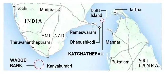
India and Sri Lanka are separated by a narrow and shallow sea known as the Palk Strait, named after Robert Palk, who served as Governor of Madras Presidency (1755-1763) during British colonial rule. The maritime boundary between these two nations is unique in South Asia due to the close proximity of their coastlines. Dhanushkodi on Tamil Nadu's coast in India is merely 32 km away from Talaimanar in Sri Lanka's Jaffna peninsula, making this one of the shortest sea distances between two countries in the region.
These two points are connected by a chain of limestone shoals and sandbanks collectively known as Adam's Bridge (also called Rama's Bridge or Rama Setu in Hindu mythology). This geological formation is believed to be partially man-made according to some historical accounts, though scientific evidence suggests it formed naturally through sedimentation processes. The shallow waters of the Palk Strait, with an average depth of just 9 meters, have historically limited maritime navigation between the Bay of Bengal and the Arabian Sea, forcing larger vessels to circumnavigate Sri Lanka.
While relations between India and Sri Lanka regarding their maritime boundary have generally been peaceful, there were tensions over the ownership of Kachchatheevu Island in the Palk Strait. This small uninhabited island, covering about 1.15 sq km, became a point of contention until 1974 when India ceded it to Sri Lanka through a bilateral agreement. The island holds religious significance due to the presence of St. Anthony's Church, which attracts pilgrims from both countries.
Today, fishing rights in the waters between India and Sri Lanka remain a sensitive issue, with frequent incidents of fishermen from Tamil Nadu being apprehended by Sri Lankan authorities for allegedly crossing the International Maritime Boundary Line (IMBL). Both countries continue to work on resolving these issues through diplomatic channels while maintaining their overall cordial relationship.
India-Sri Lanka Maritime Boundary
Strategic Importance of India's Geography and Frontiers
India's geographical positioning at the center of the Asian continent, with its extensive land borders and coastline, confers significant strategic advantages and responsibilities. The country occupies a pivotal position in South Asia, functioning as a bridge between Southeast Asia, Central Asia, and the Middle East. This central location has historical importance, having facilitated the exchange of cultures, religions, and trade for millennia, and continues to shape India's geopolitical outlook in the contemporary world.
The diverse nature of India's borders—from the high Himalayan ranges in the north to the maritime boundaries in the south—creates a complex security environment requiring tailored approaches to border management. The challenging terrain along most land borders, featuring mountains, rivers, and dense forests, presents natural barriers but also creates vulnerabilities that require sophisticated monitoring and control measures. India's approach to border security has evolved to include not just physical infrastructure like fencing and surveillance systems but also cooperative mechanisms with neighboring countries.
India's extensive coastline of 7,516.6 km, touching 13 states and Union Territories, opens up enormous opportunities for maritime trade and resource exploitation while simultaneously creating security challenges. The country's location at the head of the Indian Ocean, through which a significant portion of global energy supplies and trade passes, elevates its role in ensuring maritime security and freedom of navigation in these waters. The establishment of coastal surveillance networks, expansion of naval capabilities, and participation in regional maritime security initiatives reflect India's growing recognition of its maritime frontiers' importance.
Beyond security considerations, India's geographical extent and frontiers have profound implications for its economic development, environmental management, and cultural identity. The border regions, despite their remoteness, are increasingly viewed not as peripheral areas but as crucial zones for economic integration with neighboring countries through cross-border trade and connectivity projects. As India continues to rise as a global power, the strategic management of its geographical assets and boundaries will remain fundamental to realizing its potential on the world stage.

